


ASE - Altimetry System Error
Altimetry System Error is the difference between the altitude indicated by the altimeter and the geometric pressure altitude. In other words, ASE is the difference between the altitude indicated on the on-board or pilot equipment, or ground controller, or on aircraft systems and the actual altitude. The lower the ASE, the safer the flight!
Currently, the ASE of all aircraft in the South American and Caribbean regions is calculated at CARSAMMA’s Altimetry Laboratory, based on data obtained from a Monitoring Flight and meteorological conditions. This Monitoring flight is carried out by a specialized company that has no relationship with CARSAMMA.
During the Monitoring Flight, the aircraft must be on a straight, level flight path for twenty minutes and in the RVSM Airspace. After this flight, the specialized company sends the data to CARSAMMA that, in software developed by the FAA, the ASE (Altimetry System Error) is calculated. Then, CARSAMMA sends the ASE to the respective Civil or Military Aviation Authorities so that they can continue the aircraft approval process for RVSM operations.
One of the criteria for the aircraft to be considered “suitable” to fly in RVSM Airspace is the ASE that must not exceed the limits of ±200ft. Other criteria will also be observed by the Civil Aviation Authorities of each State, such as: crew and aircraft equipment certification.
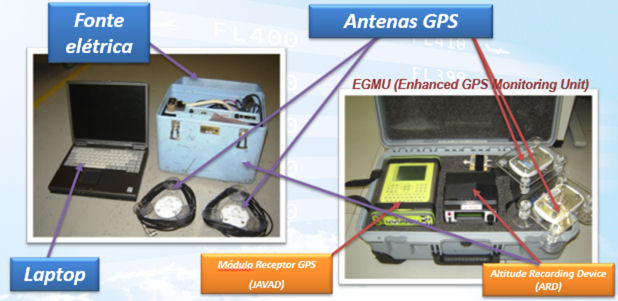
Complete GMU example – Equipment that collects Altimetry data on the Monitoring Flight.

GMU installed on board an aircraft.